Unified Development Ordinance

Article 1.5. Measurement, Exceptions & General Rules of Applicability

Article 1.5. Measurement, Exceptions & General Rules of Applicability aaron.sheppard… Mon, 05/08/2023 - 09:55

Sec. 1.5.1. Site

Sec. 1.5.1. Site aaron.sheppard… Tue, 05/23/2023 - 08:52

A. Defined
A site is any lot or group of contiguous lots owned or functionally controlled by the same person or entity, assembled for the purpose of development.
B. Site Area

  1. Gross
    Gross site area is the total area of a site, including proposed streets or other land required for public use that is attributable to the site, as dedicated by the owner or predecessor in title.
  2. Net
    Net site area is the area included within the rear, side and front lot lines of the site. Does not include existing or proposed public streets or right-of-way.

C. Site Width
Site width is the distance between the side lot lines of the site (generally running perpendicular to a street) measured at the primary street property line along a straight line or along the chord of the property line.
D. Site Depth
Site depth is the distance between the front and rear property lines of the site measured along a line midway between the side property lines.

Sec. 1.5.2. Lot

Sec. 1.5.2. Lot aaron.sheppard… Tue, 05/23/2023 - 08:53

A. Defined
A parcel of land either vacant or occupied intended as a unit for the purpose, whether immediate or for the future, of transfer of ownership or possession or for development.

B. Lot Area
Lot area is the area included within the rear, side and front lot lines. It does not include existing or proposed right-of-way, whether dedicated or not dedicated to public use. District density applies, and may require larger lots than those required for an individual building type.
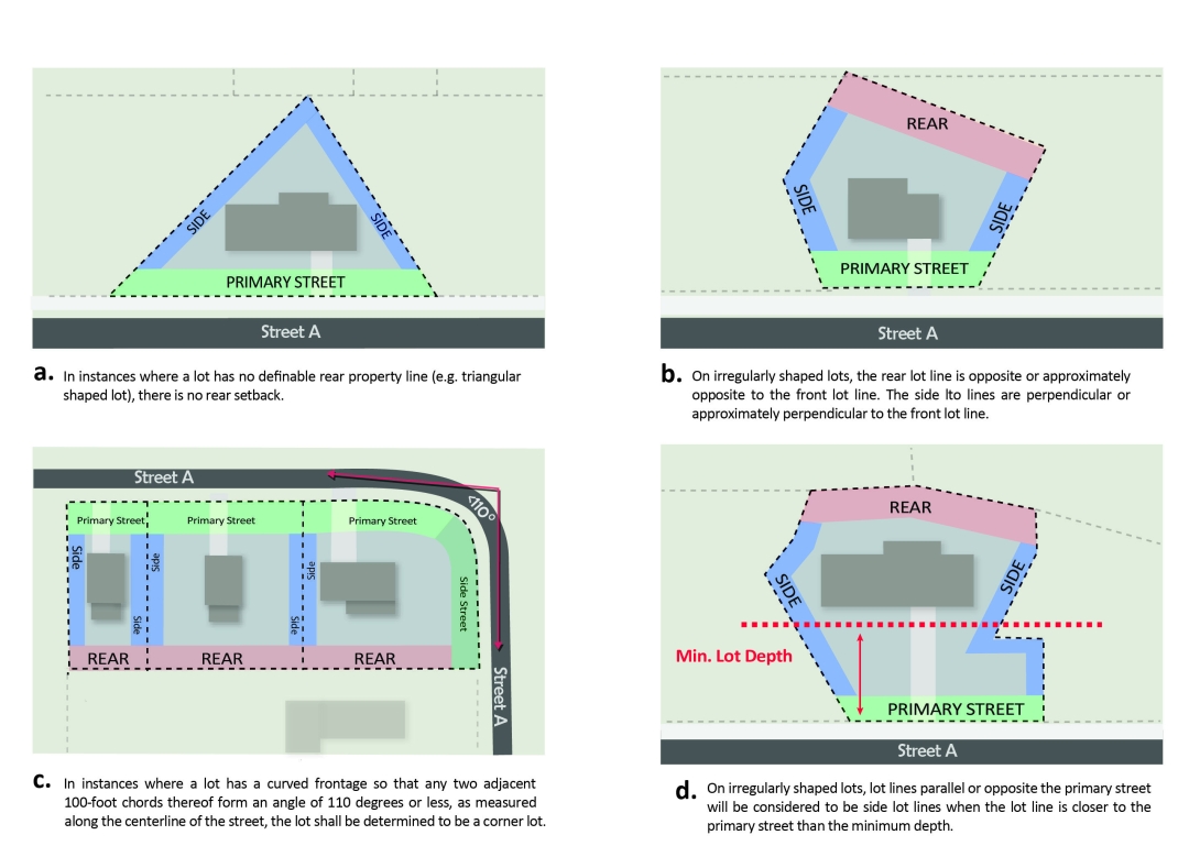
C. Lot Width
Lot width is the distance between the side lot lines (generally running perpendicular to a street) measured at the primary street property line along a straight line or along the chord of the property line. A lot must meet the minimum lot width for the entire minimum required depth of the parcel except
for cul-de-sac lots. For townhouse lots that do not front on a public street, lot width is the distance between the side lot lines (generally running perpendicular to the parking lot or drive aisle) measured at the front property line along a straight line. A lot must meet the minimum lot width for the entire depth of the parcel except for cul-de-sac lots.

D. Lot Depth
Lot depth is the distance between the front and rear property lines measured along a line midway between the side property lines.

Image
1-5-2-d-lot-depth.svg

E. Lot Width and Depth for Cul-de-Sac Lots
Any lot abutting a cul-de-sac in a Residential District where the minimum lot width is not met at the front property line must comply with the following:

  1. The minimum lot frontage on a street shall be 20 feet (this dimension may be reduced upon approval of the Development Services Director if a common driveway or other form of shared access is provided); and
  2. The minimum lot depth specified shall not be measured from the front property line, but instead measured beginning from the nearest point to front property line where the lot width equals the minimum lot width for the district. The minimum lot depth measured this way shall be 70 feet in R-1, R-2 and R-4, 60 feet in R-6 and 50 feet in R-10.

F. Density, Lot Area per Dwelling Unit, and Site Area per Dwelling Unit

  1. Residential density, where applicable, is expressed in units per acre and is calculated by dividing the total number of dwelling units by the gross site area. Unless otherwise specified herein, minimum lot sizes, minimum site areas per dwelling unit, and minimum lot areas per dwelling unit shall be the controlling factors in determining dwelling unit yields.
  2. Although minimum lot sizes may allow additional units, density, where applicable, serves as the maximum number of principal units per acre. For any lot developed with a Detached House or Tiny House used for Single-unit Living, or an Attached House or Tiny House used for Two-unit Living; one accessory dwelling unit is permitted per lot, regardless of underlying density, minimum lot size, minimum lot area per dwelling unit, or minimum site area per dwelling unit designations. For any lot developed with a Detached House or a Tiny House or an Attached House in a Frequent Transit Area, two accessory dwelling units are permitted per lot, regardless of underlying density, minimum lot size, minimum lot area per dwelling unit, or minimum site are per dwelling unit designations. For any lot developed with a Townhouse, one accessory dwelling unit is permitted per townhouse lot regardless of underlying density, minimum lot size, minimum lot area per dwelling unit, or minimum site are per dwelling unit designations.
  3. In residential districts, any area required to be dedicated for public right-of-way by the Comprehensive Plan or any area dedicated as greenway, provided that the dedicators waive their statutory right to withdraw the dedication, may be transferred to contiguous property zoned to allow dwelling units. Transfers are restricted to properties under the same ownership which are located outside any Watershed Protection Area and in the same development as the dedication for right-of-way less than 60 feet in width.
  4. A map showing the property and right-of-way dedication shall be recorded in the Wake County Registry with an indication that the roadway dedication density allowance has been utilized for the particular property prior to recording any subsequent maps in the development.
  5. No density, lot area, or site area transfer shall be allowed if the developer has executed a reimbursement contract.
  6. When a site is partly within a CM District, density, lot area, or site area may be transferred from the CM District, which carries the residential density, lot area, or site area minimums of the contiguous zoning district. If more than 1 zoning district adjoins the CM District, the CM District shall be divided by carrying the boundary lines separating the districts into the CM-zoned area.

Sec. 1.5.3. Outdoor Amenity Area

Sec. 1.5.3. Outdoor Amenity Area aaron.sheppard… Tue, 05/23/2023 - 08:53
  1. Intent
    1. Outdoor amenity areas are intended to provide usable on-site outdoor space in both residential and non-residential developments for the healthy enjoyment of occupants, invitees and guests of the development.
  2. General Requirements
    1. Where outdoor amenity area is required, it must be provided on-site and must be available for use by or as an amenity for the occupants, invitees and guests of the development.
    2. A minimum of 50% of the required outdoor amenity area must be usable to the pedestrians described in subsection 1. above. All areas usable to pedestrians must also be ADA accessible, however, this requirement shall not apply to outdoor amenity areas on the upper stories of existing buildings, allowed by Sec. 1.5.3.C.1., that do not have ADA compliant elevators or an accessible route to said amenity areas.
    3. Required outdoor amenity area may be met in 1 contiguous open area or in multiple open areas on the site ; however, to receive credit, each area must be at least 10 feet in width and length.
    4. Required outdoor amenity area may be located at or above grade.
    5. Required outdoor amenity area cannot be parked or driven upon, except for emergency access and permitted temporary events.
    6. Required outdoor amenity area may be covered but cannot be enclosed however outdoor amenity areas within the DX- district that will be covered by structures with a clear height no less than 8’ and less than the proposed minimum ground story height must account for no more than 50% of the required area. Perforated structures, where the sum area of the openings is greater than 50% or more of the surface area of the structure, shall not be considered covered for the purposes of this restriction.
    7. Green Stormwater Infrastructure (GSI) practices may be located within a required outdoor amenity area provided all other requirements of this subsection are met.Tree Conservation areas, stormwater detention wet ponds and dry ponds, slope/construction easements, riparian buffers, all protective yards, Zone A of neighborhood transitional protective yards and parking islands shall not be considered an outdoor amenity area.
    8. Sidewalk areas outside of the right-of way, even if used to satisfy streetscape requirements, shall also be eligible to count towards outdoor amenity area requirements provided all other requirements of this subsection are met.
    9. Areas outside of the right-of-way required to be set aside for required street trees shall be eligible to count towards outdoor amenity area requirements provided all other requirements of this subsection are met.
    10. Outdoor amenity areas meeting the requirements of Section 1.5.3. shall also be eligible to count towards required open space provided it also meets Article 2.5.
  3. Additional Requirements for Urban Plazas
    Amenity areas located within the DX- District; the NX-, CX- or OX- Districts with an urban frontage; or the TOD, and associated buildings in excess of 4 stories in height must meet all of the following:
    1. Outdoor amenity areas may be located on upper levels of a building however, these elevated amenity areas can account for no more than 50% of the minimum required outdoor amenity area for the site.
    2. Outdoor amenity areas shall contain at least one of the following: tables, eating areas, fountains, active recreation areas, or public art.
    3. All required outdoor amenity areas must provide one linear foot of seating for each 50 square feet of required outdoor amenity area and one two-inch caliper tree for every 1,000 square feet of required outdoor amenity area.
    4. For all buildings greater than 7 stories in height, the minimum amount of required outdoor amenity area specified in chapter 3 shall be increased. An additional 50 square feet of outdoor amenity area is required for each building story above the seventh story. In no case shall the required amenity area exceed 12% of the gross site area.
  4. Additional Exemptions/Reductions for Qualifying Projects in the DX District
    1. No outdoor amenity area is required for mixed-use buildings where nonresidential gross square footage (GSF) does not exceed 10,000 SF and where there are no more than 16 residential units proposed.
    2. No outdoor amenity area is required for residential-only buildings where there are no more than 16 dwelling units proposed.
    3. Any general building, or mixed-use building that is 50% or more nonresidential in floor area may reduce the minimum required outdoor amenity area by 50% in return for 100% of the provided amenity area being contiguous with and openly accessible from the sidewalk.
    4. The minimum amount of required outdoor amenity area can be reduced by up to 50% when modular suspended pavement systems are provided for all new required tree plantings.
  5. Design Alternate Findings
    The Planning Commission or Design Review Commission performing the quasi-judicial duties of the Planning Commission (as designated by the City Council), after conducting a duly noticed quasi-judicial evidentiary hearing in accordance with Sec. 10.2.17., shall allow outdoor amenity areas that do not conform to the outdoor amenity area regulations set forth in Sections 1.5.3.B. and/or 1.5.3.C., if all of the following findings are satisfied:
    1. The approved alternate meets the intent of the Outdoor Amenity Area regulations;
    2. The approved alternate provides usable outdoor space that does not hinder pedestrian comfort or safety; and
    3. The approved alternate uses landscaping, seating, GSI, or other features and is clearly accessible for users.

Sec. 1.5.4. Building Setbacks

Sec. 1.5.4. Building Setbacks aaron.sheppard… Tue, 05/23/2023 - 08:54
  1. Setback Types
    There are 4 types of setback – primary street setback, side street setback, side setback and rear setback. Through lots, except reverse-frontage lots, are considered to have 2 primary street setbacks. Reverse-frontage lots will designate the street from which access from adjacent lots is taken as primary. If that fails to produce a clear result, the applicant may designate either street as primary.
  2. Measurement of Building Setbacks
    1. Primary and side street setbacks are measured perpendicular from the edge of the existing or proposed right-of-way, whichever is greater.
    2. Side setbacks are measured perpendicular from the side property line.
    3. Rear setbacks are measured perpendicular from the rear property line or the edge of the existing or proposed right-of-way, whichever is greater, where there is an alley.
    4. For the irregular shaped lots described below, setbacks shall be assessed as follows:

      [Insert Image Here]
  3. Multiple Street Frontage Lots
    For the purposes of determining setbacks, build-to lines, and other regulations, a multiple street frontage site or lot other than an Open Lot must designate at least 1 primary street prior to development, not to include additions. A lot may
    have more than one primary street. The following rules determine a primary street:
    1. A lot developed with the Apartment, General, Mixed-Use or Civic building types shall designate its primary street using the criteria shown in (a) through (g) below. If one street meets any of criteria (a) through (d), it will be designated primary. If two streets meet any of criteria (a) through (d), both will be designated primary. If three or four streets meet any of criteria (a) through (d), the two streets that meet more of (a) through (d) will be designated as primary; if they meet the same number, then the applicant may choose the two streets. Where the criteria refer to a street, the relevant portion of the street is the portion adjacent to or within the site or lot. If no street meets criteria (a) through (d), then the street that that satisfies more of criteria (e) through (g) will be designated as  primary. If the criteria do not apply or do not produce a clear result, then any street may be designated as primary by the applicant.
      1. The street with transit service;
      2. The street designated as a Main Street or Urban Thoroughfare on the Urban Form Map;
      3. Any street designated as a Retail Street in the Downtown section of the Comprehensive Plan.
      4. The street designated as a Mixed-use Street on the Raleigh Street Plan Map;
      5. The street designated as a Major Street on the Raleigh Street Plan Map;
      6. The street with on-street parking;
      7. The street with the higher classification on the Raleigh Street Plan Map;
    2. A block face predominately developed with the Townhouse building type shall designate as its primary street either a Local Street or Mixed-use Street, if available. If the site fronts on more than one street meeting these criteria or if they do not apply, then the selection of primary street shall be based on the criteria for Apartment, General, Mixed-Use, or Civic buildings. Any street designated as primary must form the face of a block or extend fully through
      the property.
    3. For an Attached or Detached building, a corner lot shall designate its primary street as being opposite the rear yard of any adjoining lot. If the corner lot abuts only the side yard of adjoining lots or abuts another corner lot, then the primary street shall be located along the narrowest street frontage. If the two street frontages are within 10 percent of each other in length, either street may be designated as primary. In no case will a Major Street be designated as the primary street.
    4. A limited-access highway shall never serve as the primary street.
    5. A dead-end or cul-de-sac street can only be identified as primary for residential lots.
    6. A private street cannot be primary unless the lot has no public street frontage.
    7. In the event an adopted plan designates primary streets, the adopted plan shall control.
    8. If none of the criteria produce a result, the applicant may designate the primary street.
  4. Setback Encroachments
    All buildings and structures must be located at or behind required setbacks, except as listed below. Underground structures covered by the ground may encroach into a required setback.
    1. Building Features (attached to a structure)
      1.  Porches, decks, patios, terraces, and stoops greater than 1 foot in height may extend 12 feet into a  required side or rear setback, provided that such extension is at least 3 feet from the vertical plane of any side or rear property line. In addition, these structures may extend 9 feet into a primary or side street setback, provided that such extension is at least 3 feet from the vertical plane of any street property line.
        Patios, terraces and decks that are 1 foot in height or less may be constructed a minimum of 0 feet from the vertical plane of any side or rear property line and 3 feet from the vertical plane of any street property line.
      2. Balconies (platforms projecting from the wall of a building with a railing along its outer edge, often accessible from a door or window) may extend up to 6 feet into a required setback, provided that the landing is at least 3 feet from the vertical plane of any lot line. Balconies can be covered but cannot be fully enclosed.
      3. Galleries (covered passages extending along the outside wall of a building supported by arches or columns that are open on 1 side), must have a clear depth from the support columns to the building's façade of
        at least 8 feet and a clear height above the sidewalk of at least 10 feet. A gallery may extend into a required street setback. A gallery may not extend into a required side setback.
      4. Chimneys or flues may extend up to 4 feet, provided that such extension is at least 3 feet from the vertical plane of any lot line.
      5. Building eaves, roof overhangs, awnings and light shelves may extend up to 5 feet, provided that such extension is at least 3 feet from the vertical plane of any lot line.
      6. Bay windows, oriels, vestibules and similar features that are less than 10 feet wide may extend up to 4 feet, provided that such extension is at least 3 feet from the vertical plane of any lot line.
      7. Unenclosed fire escapes or stairways may extend up to 4 feet into a required side or rear setback, provided that such extension is at least 5 feet from the vertical plane of any lot line.
      8. Cornices, belt courses, sills, buttresses or other similar architectural features may project up to 1½ feet.
      9. Handicap ramps may project to the extent necessary to perform their proper function.
      10. If a variance is not required, a building feature may encroach into the right-of-way, provided a license for the use of the right-of-way is obtained from the authority having jurisdiction. A City license is terminable at will by the City.
    2. Mechanical Equipment and Utility Lines
      1. Mechanical equipment associated with residential uses, such as HVAC units and security lighting, may extend into a required rear or side setback, provided that such extension is at least 3 feet from the vertical plane of any lot line. Permanently installed generators associated with residential uses must meet setbacks for the primary structure in the district. A zoning permit is required for these generators.
      2. Solar panels or wind turbines may extend into a required rear or side setback, provided that such extension is at least 3 feet from the vertical plane of any lot line.
      3. Rainwater collection or harvesting systems may extend into a required rear or side setback, provided that such extension is at least 3 feet from the vertical plane of any lot line.
      4. Utility lines located underground and minor structures accessory to utility lines (such as hydrants, manholes and transformers and other cabinet structures) may extend into a required rear or side setback.
    3. Minor Structures and Improvements
      Notwithstanding the other requirements of this UDO, standalone structures or improvements that are 4 feet in height or less may be a minimum of 3 feet from any property line. Standalone patios, terraces and decks that are 1 foot in height or less may be constructed a minimum of 0 feet from the vertical plane of any side or rear property line and 3 feet from the vertical plane of any street property line. Pools and other water features may encroach into
      a required setback subject to any other building code requirements and/or limitations.
  5. Other Setback Encroachments
    1. Fence and walls under Sec. 7.2.8.
    2. Signs under Article 7.3. Signs.
    3. Driveways under Sec. 8.3.5. Site Access.
    4. Transitional and street protective yards under Sec. 7.2.4.


Image
setbacks


Supplement Number
28

Sec. 1.5.5. Parking Setbacks

Sec. 1.5.5. Parking Setbacks aaron.sheppard… Tue, 05/23/2023 - 08:54
  1. Parking Setback Types
    There are 4 types of parking setback – primary street setback, side street setback, side setback and rear setback. Through lots are considered to have 2 primary street setbacks.
  2. Measurement of Parking Setbacks
    1. Primary and side street setbacks are measured perpendicular from the edge of the existing or proposed right-of-way, whichever is greater.
    2. Side setbacks are measured perpendicular from the side property line.
    3. Rear setbacks are measured perpendicular from the rear property line or the edge of the existing or proposed right-of-way, whichever is greater, where there is an alley.
  3. Parking Not Allowed
    On-site surface and structured parking must be located behind the parking setback line, where applicable. This requirement does not apply to on-street parking or apply to upper stories of a parking deck.
  4. Parking in the Front Setback
    1. For a detached house, tiny house, or attached house located within a Residential District and used for residential purposes, combined parking and driveway area shall not constitute more than 40% of the area between the front building facade and the front property line. Any parking in the front setback must have sufficient depth so that parked cars do not encroach on the adjacent sidewalk.
    2. Additional parking regulations may be applied with the Special Residential Parking Overlay District (see Sec. 5.6.1.).

Sec. 1.5.6. Build-to

Sec. 1.5.6. Build-to aaron.sheppard… Tue, 05/23/2023 - 08:54
  1. Defined
    1. The build-to is the area on the lot where a certain percentage of the front principal building facade must be located, measured as a minimum and maximum setback range from the edge of the proposed or existing right-of-way, whichever is greater.
    2. The required percentage specifies the amount of the lot width, site width, or blockface width in the case of townhouses, that must be occupied by front building façade within the build-to range, measured based on the width of the building divided by the width of the site, lot, or townhouse blockface, whichever applies.
    3. There are 2 types of build-to -- primary street build-to and side street build-to. Through lots are considered to have at least 1 primary street build-to.The designation of the primary street build-to shall follow the rules of Sec. 1.5.4.C. No build-to is required on the non-primary street frontage of a through lot.
      Image
      1-5-6-a
  2. Intent
    1. The build-to is intended to provide a range for building placement that strengthens the street edge along the right-of-way, establishing a sense of enclosure by providing spatial definition adjacent to the street.
    2. The building edge can be supplemented by architectural elements and certain tree plantings aligned in a formal rhythm. The harmonious placement of buildings to establish the street edge is a principal means by which the character of an area or district is defined.
    3. The build-to range is established to accommodate some flexibility in specific site design while maintaining the established street edge.
       
  3. General Requirements
    1. On corner lots, building façade fronting each street must be placed within the intersecting build-to range for each street. Amenity area provided in accordance with Section 1.5.6.C.4. may be used to satisfy this requirement.
    2. With the exception of parking areas, all structures and uses customarily allowed on the lot are permitted in the build-to area.
    3. When any of the items listed below are generally perpendicular to the rightof- way and located within the applicable build-to range, lot width shall be reduced by the width of the impediment for the purposes of calculating build-to percentage. To qualify, a perpendicular impediment must reduce the build-to range to less than 10’ as detailed below. For example, a 100’ wide lot with a 20’ wide perpendicular easement would be considered an 80’ wide lot when calculating build-to percentage.
      Image
      1-5-6-c-perpendicular
      When any of the items listed below are generally parallel to the right-of-way, located within the build-to range, and reduce the build-to range to less than 5', then the build-to range shall be reduced by 50% and measured from the edge of the impediment. For example, a lot with a 17’ parallel easement and initial build-to range of 0'/20' shall be considered to have a new build-to range of 17’/27’.
       
      Image
      1-5-6-c-parallel
       
      1. Riparian Buffers
      2. Floodways
      3. Areas of steep slope (defined as slopes in excess of 25%)
      4. Required Open Space as defined in Article 2.5
      5. Required Protective Yards or Landscaped areas
      6. Portions of property encumbered by electric transmission lines rated to transmit 230Kv
      7. The additional width (up to 25') of any second driveway required by this code that must cross the build-to area
      8. Tree Conservation (proposed and recorded)
      9. Private Utility Easements (pre-established and recorded)
      10. Sight Distance Triangles
      11. Public Easements on private property, including but not limited to:
        1. Storm Drainage
        2. Sanitary Sewer
        3. Water Distribution
        4. Transit
        5. Slope
        6. Pedestrian (Sidewalk and Pedestrian Passage)
        7. Greenway
    4. The required build-to percentage may be reduced by 30% when the area that would have been otherwise occupied by building facade is substituted with an outdoor amenity area meeting the requirements of Sec. 1.5.3. For example, a 70% primary street build-to could be reduced to a 49% primary street build-to under this provision.
  4. Design Alternate Findings
    The Planning Commission or Design Review Commission performing the quasi-judicial duties of the Planning Commission (as designated by the City Council), after conducting a duly noticed quasi-judicial evidentiary hearing in accordance with Sec. 10.2.17., shall reduce the build-to requirement, if all of the following findings are satisfied:
    1. The approved alternate is consistent with the intent of the build-to regulations;
    2. The approved alternate does not substantially negatively alter the character defining street wall or establish a build-to pattern that is not harmonious with the existing built context; and
    3. The change in percentage of building that occupies the build-to area or  increased setback does not negatively impact pedestrian access, comfort or safety.

Sec. 1.5.7. Height

Sec. 1.5.7. Height aaron.sheppard… Tue, 05/23/2023 - 08:55
  1. Building Height
    1. Building height is measured from average grade to the top of the highest point of a pitched or flat roof, not including a maximum parapet wall encroachment. Building height must be met for the entire building, unless the multiple module height method is used in which case building height must be met for each module. The maximum height encroachment for a parapet wall is 4 feet for a 3-story building, with 1 additional foot of parapet wall allowed for each additional story thereafter. In no case shall a parapet encroachment be taller than 12 feet.
      Image
      1-5-7-a-1
    2. Average grade shall be determined using one of the following methods:
      1. Single Building Height Method
        1. Average grade shall be considered to be average post-development grade above sea level along the building elevation most parallel and closest to the primary street setback.
      2. Multiple Module Height Method
        1. As an alternative option to the single building height method, measurement of height for a building can be broken down into two or more building modules each with a separate average grade for the purposes of determining the height in feet and number of stories for the individual modules.
        2. Average grade for each module shall be considered to be average post-development grade above sea level along the building module elevation most parallel and closest to the primary street setback.
          Image
          1-5-7-a-2-b-ii
          Single Building Height Method
           
          Image
           1-5-7-a-2-b-single-building-height-method
          Multiple Module Height Method
          Image
           1-5-7-a-2-b-multiple-module-height-method
      3. Infill Development Height Method
        1. For any building subject to the standards of Sec. 2.2.7., average grade shall be determined by averaging the four points consisting of the highest and lowest elevations of both pre-development and postdevelopment grade above sea level along the building elevation most parallel and closest to the primary street setback. When the average post- development grade is lower than the average pre-development grade, then height shall be measured from the average post development grade.
           
          Image
          Multiple Module Elevation Simple Method

          The following subsections apply to any methodology:
    3. Where a site or lot is determined to have more than one primary street, average grade shall be determined along each building or module elevation most parallel and closest to each primary street. Maximum building or module height must be met from the average grade of each primary street independently.
      Image
       1-5-7-a-3
    4. Applicable elevation shall be determined using one of the following methods:
      1. Single Building Height Method
        1. When using the single building height method, there is only one applicable building elevation. The applicable building elevation is that which is most parallel and closest to the primary street. Any portion of the applicable building elevation that is located more than 30 feet behind the portion of the wall plane closest to the primary street shall not be included in the calculation of average grade, provided it is less than 50% of the total building elevation width.
      2. Multiple Module Height Method
        1. When using the multiple module height method, each module must establish an applicable elevation. The applicable module elevation is that which is most parallel and closest to the primary street, and20 feet or more in length. Any portion of the applicable module elevation that is located more than 30 feet behind the portion of the wall plane closest to the primary street shall not be included in the calculation of average grade, provided it is less than 50% of the total module elevation width.
          Image
           1-5-7-a-4-b-i
    5. For a detached or attached building type only, an attic does not count as a story where 50% or more of the attic floor area has a clear height of less than 7.5 feet; measured from the finished floor to the finished ceiling. To be classified as an attic, the space must also meet the specifications as provided in the defined term in Article 12.2, Defined Terms.
      Image
      Multiple Module Elevation Simple Method
    6. When 50% or more of the perimeter wall area of a detached or attached building is located below grade, the building contains a basement. The floor of this level must be located entirely below finished grade. This provision can be utilized in other building types; however, the entirety of the floor area may only be used for storage, mechanical equipment, parking, laundry or waste collection.
    7. For a detached or attached building type only, or for any building type located within the Downtown Mixed Use District, or for any building that is zoned for a maximum of three stories, where a lot slopes downward from any primary street, one story that is additional to the specified maximum number of stories may be built on the lower portion of the lot. This provision shall not be applicable for any structure that includes a basement.
      Image
      Multiple Module Elevation Simple Method
    8. Where the property slope increases to the rear, building, or building module, height is measured from the average post-development grade above sea level of the front and rear wall plane of the building or building module. However, buildings subject to the standards of Sec. 2.2.7. shall utilize the same averaging approaches in Sec. 1.5.7.A.2.c. above, in order to calculate the average grade between the pre-development average grade and the post-development average grade. When the average post-development grade utilizing both the front and rear wall planes is lower than the average pre-development grade, then height shall be measured from the average post-development grade of the front and rear wall planes.
      Image
      Multiple Module Elevation Simple Method
  2. [Reserved for future codification]
  3. Story Height
    1. Story height is measured from the top of the finished floor to top of the finished floor above.
    2. Minimum ground story height applies to the first 30 feet of the building measured inward from the street facing facade. At least 50% of the ground story must meet the minimum ground story height provisions.
    3. Where applicable, at least 80% of each upper story must meet the required minimum upper story height provisions.
    4. As a primary or accessory use, levels of a parking structure with both a ceiling and a floor shall be included when calculating the maximum number of stories.
    5. For buildings using the Multiple Module Height Method of Sec. 1.5.7.A.2.b, a higher or lower floor may be designated as the ground story for different portions of a building façade.
       
      Image
      Multiple Module Elevation Simple Method
      Image
      Multiple Module Elevation Simple Method
  4.  Height Encroachments
    Any height encroachment not specifically listed is expressly prohibited except where the Planning Director determines that the encroachment is similar to a permitted encroachment listed below.
    1.  The maximum height limits of the district do not apply to spires, belfries, cupolas, domes, bell towers, monuments, water tanks/towers or other similar structures not intended for human occupancy which, by design or function, must exceed the established height limits.
    2. The following accessory structures may exceed the established height limits, except when located within an -AOD, provided they do not exceed the maximum building height by more than 12 feet:
      1. Chimney, flue or vent stack;
      2. Unenclosed deck, patio or shade structure;
      3. Rooftop garden, landscaping;
      4. Flagpole;
      5. Parapet wall;
      6. Rainwater collection or harvesting system, and
      7. Solar panels, wind turbines.
    3. The following accessory structures may exceed the established height limits, except when located within an -AOD, provided they do not exceed the maximum building height by more than 12 feet, do not occupy more than 25% of the roof area and are set back at least 10 feet from the edge of the roof:
      1. Amateur communications tower (see Sec. 6.7.3);
      2. Cooling tower;
      3. Elevator penthouse or bulkhead;
      4. Greenhouse;
      5. Mechanical equipment;
      6. Skylights;
      7. Elevator or stairway access to roof; and
      8. Tank designed to hold liquids, except as otherwise permitted.
    4. An accessory structure located on the roof must not be used for any purpose other than a use incidental to the principal use of the building except for telecommunication facilities.

Sec. 1.5.8. Pedestrian Access

Sec. 1.5.8. Pedestrian Access aaron.sheppard… Tue, 05/23/2023 - 08:55
  1. Intent
    1. The street-facing entrance regulations are intended to concentrate pedestrian activity along the street edge and provide an easily identifiable and conveniently-located entrance for residents, visitors and patrons accessing a building as pedestrians from the street.
    2. Access points should be located or identified in a manner visible to the pedestrian from the street and be accessible via a direct path.
  2. General Requirements
    1. An entrance installed after September 1, 2013 providing both ingress and egress, operable to residents or customers at all times, is required to meet the street facing entrance requirements. Additional entrances from another street, pedestrian area or internal parking area are permitted.
    2. At least one entrance per non-residential ground floor unit is required on each public street facing façade in all urban frontages.
    3. An angled entrance may be provided at the corner of a building along the street to meet the street-facing entrance requirements.
  3. Design Alternate Findings
    1. The Planning Commission or Design Review Commission performing the quasi-judicial duties of the Planning Commission (as designated by the City Council), after conducting a duly noticed quasi-judicial evidentiary hearing in accordance with Sec. 10.2.17., shall allow a non-street-facing entrance, if all of the following findings are satisfied:
    2. The approved alternate is consistent with the intent of the street-facing entrance regulations;
    3. The pedestrian access point is easily identifiable by pedestrians, customers and visitors;
    4. Recessed or projecting entries or building elements have been incorporated into the design of the building to enhance visibility of the street-facing entrance; and
    5. The pedestrian route from the street and bus stops and other modes of public transportation to the entrance is safe, convenient and direct.

Sec. 1.5.9. Transparency

Sec. 1.5.9. Transparency aaron.sheppard… Tue, 05/23/2023 - 08:56
  1. Intent
    The transparency requirements are intended to lend visual interest to streetfacing building facades for both pedestrians and building occupants and minimize blank wall areas. This is not applicable to residential uses.
  2. General Requirement
    1. The minimum percentage of windows and doors that must cover a ground story facade is measured between 0 and 12 feet above the surface of the finished ground floor for all above-grade portions of the facade. A minimum of 50% of the required transparency must be located between 3 and 8 feet from the surface of the finished ground floor.
    2. The minimum percentage of windows and doors that must cover an upper story facade is measured from top of the finished floor to the top of the finished floor above. When there is no floor above, upper story transparency is measured from the top of the finished floor to the top of the wall plate.
    3. In a mixed use building, or general building where an Urban Frontage is applied, a minimum of 60% of the street-facing, street-level window pane surface area must allow views into the ground story use for a depth of at least 8 feet. Windows shall not be made opaque by non-operable window treatments (except curtains, blinds or shades within the conditioned space).
    4. Glass shall be considered transparent where it has a transparency higher than 80% and external reflectance of less than 15%. Glass on upper stories may have any level of transparency and external reflectance.
       
      Image
      Glass Transparency
  3. Design Alternate Findings

The Planning Commission or Design Review Commission performing the quasi-judicial duties of the Planning Commission (as designated by the City Council), after conducting a duly noticed quasi-judicial evidentiary hearing in accordance with Sec. 10.2.17., shall reduce the required transparency, if all of the following findings are satisfied:

  1. The approved alternate is consistent with the intent of the transparency
    requirements; and
  2. The street-facing building facade utilizes other architectural, artistic, or
    landscaped treatments to create visual interest to offset the reduction in
    transparency.

Sec. 1.5.10. Blank Wall Area

Sec. 1.5.10. Blank Wall Area aaron.sheppard… Tue, 05/23/2023 - 08:56
  1. Defined
    1. Blank wall area means any portion of the street-facing facade(s) of the building that does not include a substantial material change; windows or doors; or columns, pilasters or other articulation greater than 12 inches in depth.
    2. Substantial material change means a change between materials such as wood, metal, glass, brick, architectural block, stone or stucco. Substantial material change should occur at an inside corner, where feasible. Paint color is not a substantial material change.
  2. Intent
    1. The blank wall area regulations are intended to prevent large, monotonous expanses of undifferentiated building mass.
    2. The level of architectural detail should be most intense at the street level, where it is within view of the pedestrians on the sidewalk.
  3. General Requirements
    1. Blank wall area applies in both a vertical and horizontal direction.
    2. Blank wall area applies to both ground and upper stories.
      Image
      Blank Wall Area
  4. Design Alternate Findings
    The Planning Commission or Design Review Commission performing the quasi-judicial duties of the Planning Commission (as designated by the City Council), after conducting a duly noticed quasi-judicial evidentiary hearing in accordance with Sec. 10.2.17., shall approve additional blank wall, if all of the following findings are satisfied:
    1. The approved alternate is consistent with the intent of the blank wall area regulations;
    2. The increase in blank wall area is offset by additional architectural treatments and increased vertical landscaping;
    3. The approved alternate proposes a design compatible with adjacent context and does not produce adverse outcomes for neighbors or pedestrians.
    4. The approved alternate uses blank wall to elevate the overall design.

Sec. 1.5.11. Reserved

Sec. 1.5.11. Reserved aaron.sheppard… Tue, 05/23/2023 - 08:57

Sec. 1.5.12. National Register Historic District Residential Garage Parking Options

Sec. 1.5.12. National Register Historic District Residential Garage Parking Options aaron.sheppard… Tue, 05/23/2023 - 08:57
  1. Intent
    1. The intent of the residential garage options is to minimize the visual impact of street-facing garage doors.
    2. Where garage doors can be seen from the street, measures should be taken to reduce the visual impact of the doors.
    3. Measures include garage doors set back from the front wall plane, architectural treatments, translucent garage doors, single doors, projecting elements over the garage doors (such as bay windows) and limits on the total number of doors that face the street.
    4. Where garage doors are located perpendicular to the street, measures should be taken to reduce the visual impact of the side wall that faces the street. Measures include architectural treatments, changes in material, landscaping, vegetation or the installation of windows.
  2. Applicability
    1. Any private residential garage located in a National Register Historic District, but not in a General Historic Overlay District, Streetside Historic Overlay District or a City of Raleigh designated Historic Landmark, constructed after September 1, 2013, must meet the standards of this section.
    2. In addition to the standards provided in this section, attached and detached garages must meet all applicable requirements for either principal buildings or accessory structures as set forth in this UDO.
    3. Any garage constructed prior to September 1, 2013 that does not comply with these private residential garage parking options is not considered non-conforming. If a pre-existing garage is voluntarily demolished, any new garage must be constructed in compliance with these regulations. If a preexisting garage that does not meet these regulations is destroyed following a casualty, the garage may be reconstructed to its previous state.
  3. Design Alternate Findings
    The Planning Commission or Design Review Commission performing the quasi-judicial duties of the Planning Commission (as designated by the City Council), after conducting a duly noticed quasi-judicial evidentiary hearing in accordance with Sec. 10.2.17., shall approve an alternate garage option, if all of the following findings are satisfied:
    1. The approved alternate is consistent with the intent of the garage option regulations;
    2. Measures are taken to mitigate the visual impact of the garage design; and
    3. The required garage setbacks are met
  4. Detached House and Attached House
    On lots of less than 1 acre, garage placement must match one of the following standards.
    1. Front-facing, Attached to House
      1. Garage doors are oriented towards the front wall plane.
      2. For garage doors positioned 6 feet or less behind the front wall plane of habitable space, garage doors may not comprise more than 50% of the overall width of the front-facing wall planes of the house.
      3. For garage doors positioned more than 6 feet behind the front wall plane of habitable space, garage doors may not comprise more than 66% of the overall width of the front-facing wall planes of the house.
    2. Side-facing, Attached to House
      1. Garage doors are oriented perpendicular to the front wall plane.
      2. The garage may not comprise more than 66% of the overall width of all front-facing wall planes of the house.
    3. Detached
      Garage is placed no closer to the primary street or the side street than the principal structure's closest wall plane to the street.
    4. Alley-Loaded
      1. Garage is placed entirely to the rear of the house and is alley-accessed.
      2. Garage doors must face the alley.
      3. The garage must either be located 4 feet from the alley right-of-way or be a minimum of 20 feet from the alley right-of-way.
      4. Where parking spaces are located between the garage and the alley, the garage must be located at least 20 feet from the alley right-of-way.
         
        Image
        Alley Loaded image 1
         
        Image
        Alley Loaded image 2
         
        Image
        Alley Loaded image 3
         
        Image
        Alley Loaded image 4
  5. Townhouse
    1. Rear-Loaded
      1. Garage is placed entirely to the rear of the townhouse and is rearaccessed. Garage can be attached or detached.
      2. The garage must either be located 4 feet from the alley right-of-way or easement or rear access drive or be a minimum of 20 feet from the alley right-of-way or easement or rear access drive.
      3. Where parking spaces are located between the garage and the alley or rear access drive, the garage must be located at least 20 feet from the alley or rear access drive.
    2. Front-Loaded
      1. Garage doors may constitute no more than 50% of the width of the individual townhouse unit.
      2. Combined parking and driveway area shall not constitute more than 50% of the area between the front building facade and the front property line.
      3. Any parking in the front setback must have sufficient depth so that parked cars do not encroach on the adjacent sidewalk. To provide sufficient depth, the garage doors must be set back at least 20 feet from the sidewalk.
      4. Garage doors must be recessed at least 1 foot behind the front wall plane or a second-story element over the garage doors must be provided that extends at least 1 foot beyond the front wall plane.

         
        Image
        townhouse front loaded image 1
         
        Image
        townhouse front loaded image 2
         
        Image
        townhouse front loaded image 3