- The intent of the maximum block perimeter and connectivity regulations is to provide a well-connected street network.
- Large blocks with limited connectivity discourage walking, contribute to street congestion and add driving distance that can negatively impact emergency services. New streets should be designed to consider future development.
- The access regulations are intended to provide a means for safe, efficient and convenient vehicular and pedestrian access within developments and between adjacent developments and to lessen traffic congestion. Pedestrian, bike and vehicular access should be safe, direct and convenient.
- A conditional zoning applicant may in accordance with Sec 10.2.4 E.2 offer zoning conditions and supporting documents sufficient to demonstrate to the City Council that development plans submitted to the City will provide for safe, efficient and convenient vehicular, bicycle and pedestrian circulation.
Article 8.3. Blocks, Lots, Access
Sec. 8.3.1. Intent
Sec. 8.3.2. Blocks
- Block Perimeters
- Applicability
- Except as set forth in Section 8.3.2.A.1.b. below, the block perimeter standards apply to preliminary subdivision plans, final plats and site plans submitted in accordance with Sec. 10.2.5. and Sec. 10.2.8. These standards can be modified by a zoning condition contained in an adopted conditional zoning ordinance, or a design alternate authorized in this UDO.
- Except where a street connection traversing the subject property is shown on the Raleigh Street Plan or an adopted Area Plan, compliance with the maximum block perimeter standards, including maximum dead-end street length, shall not be required when one or more of the following conditions are met:
- The site to be developed is below the minimum applicable site area established in the table found in Sec. 8.3.2.A.2.b
- The resulting street connection, if completed, would neither reduce the perimeter of the oversized block by at least 20 percent nor result in conforming block perimeters.
- The resulting street connection, if completed, would result in a new block perimeter less than 50 percent of the maximum block perimeter length.
- The new street or street stub right-of-way, including utility placement easement, would consume more than 15 percent of either the area of the impacted adjacent property or the property to be developed
- A sealed traffic study is submitted substantiating that the street connection would lead to an intersection level of service within a residential zoned area of Level of Service (LOS) E or F, exclusive of intersections with major streets as designated on the City's adopted street plan.
- The creation (on the property to be developed) or continuation (on an adjacent property) of any new street or street stub would be obstructed by any of the following:
- existing improvements where the value of such improvements is more than the land value of the parcel on which the improvements are located;
- railroad, or controlled access highway;
- watercourse that has one (1) square mile of drainage area or more; or
- previously established tree conservation area, open space or public park.
- Blocks recorded on or before September 1, 2013, whose block perimeter length does not exceed 150% of the maximum established in Sec. 8.3.2.A.2.b.
- North Carolina Department of Transportation denies a driveway permit necessary to make the street connection.
- The property to be developed or the adjacent property to which any new street or stub street would be continued contains one or more of the following land uses: historic landmark, cemetery, landfill, hospital, school (public or private (k-12)), college, community college, university, places of worship, police station, fire station, EMS station, prison or any residential use in an Attached, Tiny House, or Detached building type on lots no larger than 2 acres.
- Block Standards
- Residential blocks must have sufficient width to provide for 2 tiers of residential lots, except where single tier lots are required to accommodate single-loaded streets where across from a public park
or open space, to allow for unusual topographical conditions or when adjacent to the outer perimeter of a subdivision. The following table establishes the maximum block perimeter and maximum length for a dead-end street by zoning district. In the event that a single block contains more than 1 zoning district, the least
restrictive requirement applies.
Block Perimeter (max) Dead-End Street (max) Min. Site Area Applicable (acres) R-1, R-2, R-4, R-6: By Average Lot Size on Block 40,000+ sf 8,000' 1,000' 34 20,000 - 39,999 sf 6,000' 750' 19 10,000 - 19,999 sf 5,000' 600' 13 6,000 - 9,999 sf 4,500' 550' 11 up to 5,999 sf 3,000' 400' 5 R-10: By District R-10 2,500' 300' 3 Mixed Use Districts DX-, -TOD 2,000' Not allowed 2 RX-, NX-, CX-, OX-: up to 4 stories 3,000' 400' 5 RX-, NX-, CX-, OX-: 5+ stories 2,500' 300' 3 OP-, IX- 4,000' 500' 9 Special Districts CM, AP n/a n/a n/a IH n/a n/a n/a MH 3,000' 400' 5 CMP, PD 4,000' unless established in master plan 500' unless established in master plan 9 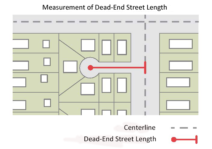
- Residential blocks must have sufficient width to provide for 2 tiers of residential lots, except where single tier lots are required to accommodate single-loaded streets where across from a public park
- Applicability
- Block Measurement
- A block is bounded by a public right-of-way (not including an alley). All public rights-of-way proposed as part of a development must be improved with a street.
- Block perimeter is measured along the edge of the property adjoining the public right-of-way. Dead-end streets are measured from intersecting centerlines.
- The maximum block perimeter shall be permitted to extend by 100% where the block includes a pedestrian passage (see Sec. 8.5.8.) that connects the two streets on opposing block faces including pedestrian passages and alleys that connect dead-end streets. A property where an existing alley meets the 50% extension shall be deemed to meet block perimeter.
- A block shall be permitted to be broken by a civic building or open lot, provided the lot is at least 50 feet wide and deep and provides a pedestrian passage meeting the requirements of Sec. 8.5.8. that directly connects the two streets on each block face.
- Within a single phase of any subdivision or development, individual block perimeters shall be permitted to exceed the maximum by 25% provided that the average of all block perimeters in the phase does not exceed the maximum.
Where the block pattern is interrupted by public parkland, including greenways, that is open and accessible to the public, pedestrian access points shall be provided with a minimum spacing equal to ½ of the maximum block perimeter.

- Nothing in this provision would allow a public street stub to be extended as a pedestrian passage. When a public street is stubbed to a property and block perimeter is not met on that property, a pedestrian passage may not be used to meet block perimeter.
TC Number
TC-11-24
Ordinance Number
785 TC 491
Sec. 8.3.3. Lots
- Lot Frontage
Every lot shall have frontage on a public street, with the following exceptions:
- Lots as part of a development which was approved for private streets prior to the effective date of this UDO.
- Individual lots within a Cottage Court that meet the requirements of Sec. 2.6.1.
- A townhouse lot or townhouse building/structure may front on parking lots or drive aisles, provided that the entrance of each townhouse unit is located within 300 feet of the intersection of an access point and a dedicated public street.
Except as otherwise stated in this UDO, all lots must front on a street that has a pavement width of at least 20 feet.
- Lot Arrangement
- Lots shall be subdivided to permit conformance with all laws and ordinances and to ensure for orderly urban growth, proper building arrangement and to provide City services and facilities.
- Lot dimensions shall provide for the potential development of all lots and future compliance with the development standards of this UDO.
- Principal Structures Per Lot
In the R-1, R-2, R-4 and R-6 districts, only 1 principal structure is permitted per lot. This does not include cottage courts, townhomes and apartments, condominiums or specifically allowed nonresidential uses as set forth in Sec. 6.1.4. - Lot Dimensions
Lots that are occupied or are intended to be occupied shall conform with the minimum lot size, lot width and lot depth requirements provided under Chapter 2. Residential Districts, Chapter 3. Mixed Use Districts and Chapter 5. Overlay Districts. - Recombination of Lots
The recombination of lots shall be done in accordance with Sec. 10.2.6.
Sec. 8.3.4. Subdivision Access
- Open Access
Subdivisions must provide roadways that remain permanently open to the public and provide community-wide access as part of an overall connected street network. - Connectivity Required
Proposed streets must be interconnected and must connect with adjacent streets external to the subdivision in order to provide multiple routes for pedestrian and vehicle trips from, to and within the subdivision. - Stub Streets
- The following stub street standards listed below shall apply, unless:
- The standards described in Sec. 8.3.2.A.1.b are applicable, except for subsections b.i and b.vii;
- An adopted conditional zoning ordinance contains a zoning condition as allowed in Sec. 10.2.4.E.2.c; or
- A design alternate has been granted.
- Where a development adjoins unsubdivided land, stub streets within the new subdivision shall be extended to the meet maximum block perimeter standards of Sec. 8.3.2.
- The stub street must be extended to the boundary of the abutting property to the point where the connection to the anticipated street is expected.
- Stub streets must be located so that the portion of the block perimeter located on the subject property does not exceed 50% of the applicable block perimeter maximum.
- If a stub street exists on an abutting property, the street system of any new development plan must connect to the stub street to form a through street.
- When the entirety of a creek crossing is in the subdivision, the crossing must be in a single phase in its entirety.
When stubbing to the edge of the site, the stub street will be built to the furthest point possible without NCDEQ approval and a fee in lieu of construction is paid for the remainder. Any right-of-way and slope easements needed to build the connection shall be dedicated.

- Where a stub street is provided, a barricade using a design approved by the Development Services Director must be constructed at the end of the stub street, pending the extension of the street into abutting property. A sign noting the future street extension shall be posted at the applicant’s expense.
- The following stub street standards listed below shall apply, unless:
Sec. 8.3.5. Site Access
- General Access Requirements
- All existing and proposed development must provide vehicular, pedestrian and bicycle ingress and egress to and from a street or an abutting site.
- All on-site parking areas must have vehicular access from a street, an alley, a drive aisle or a cross-access easement.
- All on-site parking areas must be designed to allow vehicles to enter and exit the parking area in a forward motion, unless otherwise approved by the Development Services Director. An improved alley may be used as maneuvering space for access to on-site parking areas.
- Pedestrian Access
- All existing and proposed development must provide ADA compliant pedestrian access connecting main entrances of buildings, establishments or uses on a site that allows for public access, with all other public entrances and with available access points including parking, streets, sidewalks and transit stops with the exception of the following uses which are exempt:
- Single- or two-unit living;
- Multi-unit living with 6 or fewer dwelling units;
- Agricultural use;
- Parks, open space and greenways;
- Cemetery;
- Telecommunication tower;
- Off-premise sign;
- Minor utilities;
- Prisons; and
- Other uses not containing a principal building on the premise (with the exception of a parking facility).
- Pedestrian access shall consist of an accessible, easily-discernible and ADA compliant walkway or multi-use path with a minimum width of 5 feet.
- The pedestrian access surface located on private property shall be constructed of concrete, asphalt or other ADA approved fixed, firm and nonslip material as approved by the Development Services Director.
- Pedestrian access routes between buildings and public rights-of-way shall be physically separated from vehicular surface areas, except where required to cross a drive aisle; such crossings shall be perpendicular wherever practicable.
- Site plans containing multiple principal buildings shall submit a phasing plan. The phasing plan shall include all necessary elements to address phasing of walkway construction for the existing principal buildings and uses on the site as new buildings and building expansion occurs in the future.
- All existing and proposed development must provide ADA compliant pedestrian access connecting main entrances of buildings, establishments or uses on a site that allows for public access, with all other public entrances and with available access points including parking, streets, sidewalks and transit stops with the exception of the following uses which are exempt:
- Driveways
- All Driveways
- All driveway design and construction must comply with the Raleigh Street Design Manual, or the Fire Code when conflict exists.
Driveway dimensions measured at the street right-of-way shall be in accordance with the following table:
Width (min) Width (max) Radius (max) Residential on a local street, up to 6 off-street parking spaces 10' 18' 10' Residential 7+ off-street parking spaces (one way) 12' 16' 10' Residential 7+ off-street parking spaces (two-way) 20' 24' 10' Mixed Use/Commercial (one-way) 12' 18' 12' Mixed Use/Commercial (two-way) 20' 32' 15' Industrial/Service 30' 40' 30' - Wider driveways shall be allowed where:
- required by the turning radii of vehicles accessing the site or to accommodate existing topography as certified by a licensed design or engineering professional; or
- a traffic report certified by a licensed design or engineering professional indicates the need for a wider driveway.
- Nothing in this section shall prevent all site access to any property.
- Driveways for Residential Uses
Residential driveway spacing standards are only applicable to driveways serving a maximum of two dwelling units. All other development types are subject to Nonresidential standards. Unless modified by a zoning condition
contained in an adopted conditional zoning ordinance or a design alternate authorized in this UDO, the regulations in subsection C.2 shall apply.- When an improved alley with a width of at least 20 feet is provided, all vehicular access shall take place from the alley. Access may be taken from the side street on corner lots.
- Except for townhouse lots, tiny house lots and flag lots (including their residual lots), all lots 40 feet or less in width platted after the effective date of this UDO are required to take vehicular access from an alley or a driveway shared with another lot.
- No residential lot may have more than 2 driveways on the same street. Multiple driveways that service 1 lot may be no closer than 40 feet to each other.
- Non-alley loaded driveways may intersect a street no closer than 20 feet from the intersection of 2 street rights-of-way.
- Parking and driveway areas shall not constitute more than 40% of the area between the front building line and the front property line with the exception of lots used for Tiny Houses (including Flag Lots).
- A driveway serving a tiny house lot or flag lot (including their residual lots) shall either be shared with another lot or meet the minimum spacing requirements as specified in the Raleigh Street Design Manual.
- Driveways for Mixed Use and Nonresidential Uses
Unless modified by a zoning condition contained in an adopted conditional zoning ordinance or a design alternate authorized in this UDO, the regulations in subsection C.3 shall apply.- If on-site parking areas can be accessed from an improved alley with a right-of-way of at least 24 feet in width, access from the alley is required and new curb cuts along the public right-of-way are not allowed.
- Driveways are allowed based on the property frontage of any street. Additional driveways require approval from the Development Services Director.
- Driveways accessing up to 80-foot wide street rights-of-way must be spaced 200 feet apart centerline to centerline and driveways accessing more than an 80-foot wide street right-of-way must be spaced 300 feet apart centerline to centerline.
- A driveway serving any non-residential use or multi-unit living shall not be permitted to access neighborhood yield or neighborhood local streets unless the proposed access point is the lesser of 300’ from an avenue, boulevard or parkway, or the intersection of another public street.
- Offers of cross-access shall be prohibited where a proposed non residential use or multi-unit living may potentially obtain access from a neighborhood or residential street, unless the resulting access meets the
provisions of subsection d above. - Driveways may intersect a street no closer than 50 feet from the intersection of two street rights-of-way, not including an alley.
- Service and loading driveways integrated into a building or parking structure are exempt from the driveway spacing requirements. Parking structure driveways for passenger vehicle ingress/egress are subject to spacing requirements consistent with Raleigh Street Design Manual -Chapter 3, shown on each street cross-section.
- All Driveways
- Cross-Access
All lots abutting a street other than a local street shall comply with the following standards:- Internal vehicular circulation areas shall be designed and installed to allow for cross-access between abutting lots.
- When an abutting owner refuses in writing to allow construction of the internal vehicular circulation on their property, a stub for future cross-access shall be provided as close as possible to the common property line.
- Rights of vehicular and pedestrian access shall be granted to all abutting properties contemporaneously with the recording of the final subdivision plat or prior to issuance of a building permit for an approved site plan,
whichever event first occurs on the property after September 1, 2013. This right of cross-access shall be recorded by plat in the register of deeds office in the county where the property is located. By the end of the next business
day following the recordation, the applicant shall provide to Development Services evidence of recordation of the cross-access agreement. No building permit will be issued until evidence of recordation of the cross-access
agreement is provided to the City. - The content of the cross-access agreement required by the City shall be as follows:
- Pedestrian and vehicular access is granted to all properties on the same block face as the property owner establishing the cross-access. The owner may make the pedestrian and vehicular access contingent upon
the granting of reciprocal vehicular and pedestrian access right to the granting property. - The location of the pedestrian and vehicular access is described as over all sidewalks, vehicular drives and driveways located on the property which are designated to be used by the public or by specific metes and bounds.
- The beneficiaries granted access rights include the lot owners, their successors, heirs and assigns, tenants and subtenants, lenders, employees, customers and guests.
- Each lot owner is required to maintain the vehicular and pedestrian access areas on their lot. Maintenance shall include, but not be limited to repair, fixing potholes and repaving.
- All lot owners and tenants granted vehicular and pedestrian access rights shall have the right together with their contractors, but not obligation, to maintain all portions of pedestrian vehicular and access ways. If such owners, tenants and their contractors engage in any maintenance activities off their lot, they shall have the right of contribution to be reimbursed for their actual expenses from the defaulting lot owner, provided at least 30 days prior written notice is first provided to the defaulting lot owner.
- A temporary construction easement is granted to the abutting lot owner and tenants and their contractors to enter the adjoining property to install connecting internal drives not previously extended to the property line.
- A notice provision explaining how and where to send written notice.
- A provision prohibiting the erection of fences walls and other obstructions that prevent the use of vehicular and pedestrian access ways.
- A statement that the cross access agreement runs with the land and it is binding on all successors, heirs and assigns and that the easement rights are perpetual.
- A statement that the cross access agreement is a requirement of the Raleigh City Code and that it may not be terminated or amended without the written consent of the Transportation Director and such amendments and terminations that are in violation of the Raleigh City Code are void ab initio.
- The cross access agreement shall be signed by all of owners of the granting property.
- All lenders and their trustees with interests in the granting property shall subordinate their security interests to the cross access agreement.
- The cross access agreement must be certified by an attorney licensed to practice law in the State of North Carolina, confirming compliance with all of all provisions of Sec. 8.3.5.D.
- Pedestrian and vehicular access is granted to all properties on the same block face as the property owner establishing the cross-access. The owner may make the pedestrian and vehicular access contingent upon
- Cross-access requirements described in Sec. 8.3.5.D. shall not apply when one or more of the following conditions are met:
- The abutting property (to which a driveway is to be stubbed) is in a residential zoning district (except for R-10) or occupied by an Attached, Detached or Townhouse building type.
- The creation (on the property to be developed) or continuation (on an adjacent property) of any cross access driveway or driveway stub would be obstructed by any of the following:
- existing improvements where the value of such improvements is more than the land value of the parcel on which the improvements are located;
- railroad, or controlled access highway;
- steep slopes in excess of 25% within 10 feet of the property line,
- watercourse that has one (1) square mile of drainage area or more; or
- previously established tree conservation area, open space or public park.
- The property to be developed or the adjacent property to which any cross access driveway or driveway stub would be continued contains one or more of the following land uses: historic landmark, cemetery, landfill, hospital, school (public or private (k-12)), college, community college, university, places of worship, police station, fire station, EMS station or prison.
Sec. 8.3.6. Design Alternates Relating to Blocks, Lots and Access
- The Planning Commission or Design Review Commission performing the quasi judicial duties of the Planning Commission (as designated by the City Council) shall conduct a duly noticed, evidentiary hearing, in accordance with Sec. 10.2.18, and approve a design alternate from the provisions of Sec. 8.3.2, 8.3.4 and 8.3.5 relating to blocks, lots and access, upon a showing of all of the findings set forth below:
- The approved design alternate is consistent with the intent of Sections 8.3.2, 8.3.4 and 8.3.5;
- The approved design alternate does not increase congestion or compromise safety;
- The approved design alternate does not conflict with an approved or built roadway construction project adjacent to or in the vicinity of the site (no design alternate shall be approved when the City Council has authorized a roadway project in the vicinity, where the roadway design has not yet been finalized); and
- The design alternate is deemed reasonable due to one or more of the following:
- Given the existing physical environment, compliance is not physically feasible;
- Compliance would not meaningfully improve connectivity;
- Compliance is not compatible with adjacent use[s]; or
- The burden of compliance is not reasonable given the size of the site or intensity of the development.