The official title of this document is Part 10: Unified Development Ordinance for the City of Raleigh, North Carolina and is referred to throughout this document as "this UDO.”
The official title of this document is Part 10: Unified Development Ordinance for the City of Raleigh, North Carolina and is referred to throughout this document as "this UDO.”
This UDO was adopted on February 18, 2013 and became effective on September 1, 2013 by Ordinance No. 2013 151 TC 357 (TC-3-12).
This UDO is adopted to preserve, protect and promote the public health, safety and general welfare of residents and businesses in the City. More specifically, this UDO is adopted to achieve the following objectives:
The Comprehensive Plan serves as the basic policy guide for development under this
UDO. The policies and action items of the Comprehensive Plan may be amended
from time to time to meet the changing requirements of the City in accordance with
the standards and procedures in Sec. 10.2.2.
The requirements of this UDO are considered to be the minimum requirements for
the promotion of the public health, safety and general welfare.
Unless otherwise specifically stated herein, conflicts and duplications among portions of this UDO shall be resolved in favor of the more stringent regulation.
Notwithstanding anything contained herein to the contrary, and pursuant to N.C.G.S. §160A-75, the adoption, amendment, or repeal of any ordinance or development regulation requiring a public hearing under §160D-601 shall be approved upon receipt of no less than five (5) affirmative votes by City Council on the date of introduction or thereafter.
Enforcement may be by any one or more of the following methods and the institution of any action under any of these methods shall not relieve any party from any other civil or criminal proceeding prescribed for violations and prohibitions.
No existing building or structure constructed prior to September 1, 2013 shall be considered a nonconforming structure based on any of the following provisions:
The following external manuals contain technical requirements and are maintained by the City and referenced in this UDO:
Representation shall be provided by appointing at least one resident of the entire extraterritorial planning and development regulation area to the Planning Commission, Board of Adjustment, and Design Review Commission, as well as the Raleigh Historic Development Commission if there are historic districts or designated landmarks in the extraterritorial area.
Where an approved zoning condition conflicts with a standard of the corresponding general use district, the following shall apply.
The following general use zoning districts are established and applied to property as set forth on the Official Zoning Map.
Residential Districts
R-1 Residential-1
R-2 Residential-2
R-4 Residential-4
R-6 Residential-6
R-10 Residential-10
Mixed Use Districts
RX- Residential Mixed Use
OP- Office Park
OX- Office Mixed Use
NX- Neighborhood Mixed Use
CX- Commercial Mixed Use
DX- Downtown Mixed Use
IX- Industrial Mixed Use
Special Districts
CM Conservation Management
AP Agricultural Productive
IH Heavy Industrial
MH Manufactured Housing
CMP Campus
PD Planned Development
The following conditional zoning districts are established and applied to property as set forth on the Official Zoning Map. Each conditional district (bearing the designated CU on the Official Zoning Map) corresponds to a general use district. All zoning requirements that apply to the general use district are also applicable to the corresponding conditional district unless adopted conditions are more restrictive.
Residential Districts
R-1-CU Residential-1
R-2-CU Residential-2
R-4-CU Residential-4
R-6-CU Residential-6
R-10-CU Residential-10
Mixed Use Districts
RX-CU Residential Mixed Use
OP-CU Office Park
OX-CU Office Mixed Use
NX-CU Neighborhood Mixed Use
CX-CU Commercial Mixed Use
DX-CU Downtown Mixed Use
IX-CU Industrial Mixed Use
Special Districts
CM-CU Conservation Management
AP-CU Agricultural Productive
IH-CU Heavy Industrial
MH-CU Manufactured Housing
CMP-CU Campus
PD-CU Planned Development
The following overlay districts are established and applied to property as set forth on the Official Zoning Map.
-AOD Airport Overlay District
-MPOD Metro-Park Overlay District
-UWPOD Urban Watershed Protection Overlay District
-FWPOD Falls Watershed Protection Overlay District
-SWPOD Swift Creek Watershed Protection Overlay District
-SHOD-1 Special Highway Overlay District -1
-SHOD-2 Special Highway Overlay District -2
-HOD-G General Historic Overlay District
-HOD-S Streetside Historic Overlay District
-NCOD Neighborhood Conservation Overlay District
-TOD Transit Overlay District
-SRPOD Special Residential Parking Overlay District
The following districts are referred to as legacy districts. These districts exist in the Part 10 Zoning Code, and will eventually be replaced with a UDO zoning district. No new legacy district may be added to the Official Zoning Map, nor may any boundary of an existing legacy district be modified. These legacy districts may exist as a general use district or as a conditional district.
R-15 Residential-15
R-20 Residential-20
R-30 Residential-30
SpR-30 Special Residential-30
RB Residential Business
O&I-1 Office and Instituion-1
O&I-2 Office and Instituion-2
O&I-3 Office and Instituion-3
BC Buffer Commercial
SC Shopping Center
NB Neighborhood Business
BUS Business
TD Thoroughfare District
I-1 Industrial-1
I-2 Industrial-2
DOD Downtown Overlay District
PBOD Pedestrian Business Overlay District
PDD Planned Development District
SHOD-3 Special Highway Overlay District-3
SHOD-4 Special Highway Overlay District-4
| The following building types have been established to allow for detailed regulation of the form within each zoning district. All graphic depictions of building types are for illustrative purposes only. |

|
| A. Detached House A building constructed to accommodate 1 dwelling unit on a single lot. A series of detached houses as part of a cottage court may be located on a single lot. In a Mixed Use District, a detached house may be used for nonresidential purposes. |

|
| B. Attached House A building constructed to accommodate 2 principal dwelling units on a single lot. A series of attached houses as part of a cottage court may be located on a single lot. In a Mixed Use District, an attached house may be used for nonresidential purposes. |

|
| C. Townhouse A building constructed to accommodate 2 or more dwelling units that are horizontally integrated where each dwelling unit is separated vertically by a party wall. Units may be placed on individual lots or 1 or more townhouse building types may be placed on a single lot. In a Mixed Use District, a townhouse may be used for nonresidential purposes. |

|
| D. Apartment A building constructed to accommodate 3 or more dwelling units that are vertically or horizontally integrated. A common kitchen is allowed. A limited set of non-residential uses may be allowed in ground floor corner units in a Mixed Use District. Non-residential uses may be allowed on the ground floor in the Transit Overlay District, however, in no instance shall non-residential principal uses in an apartment building, or buildings, exceed 10,000 square feet in gross floor area on any one lot. |

|
| E. General Building A building constructed to accommodate nonresidential uses on all floors. |

|
| F. Mixed Use Building A multi-story building constructed to accommodate retail on the ground floor and uses in addition to retail on the upper floors. |

|
| G. Civic Building A building that in residential zoning districts exclusively accommodates civic uses, as well as rest homes, day care centers, life care, congregate care, special care facilities and accessory uses. Land uses otherwise allowed in the applicable zoning district are allowed in civic buildings in nonresidential zoning districts. |

|
| H. Open Lot Open lots are used to accommodate uses with large outdoor or open areas. An open lot can also accommodate open space, parks or natural areas. |

|
| I. Tiny House A building with a building footprint no greater than 800 square feet and no greater than 1200 square feet gross floor area constructed to accommodate 1 or 2 principal dwelling units on a single lot. A series of tiny homes as part of a cottage court may be located on a single lot. |
Building types are allowed by district as set forth below.
|
House |
House |
|
|
Building |
Building |
Building |
|
|
|
|---|---|---|---|---|---|---|---|---|---|
| Residential Districts | |||||||||
| Residential-1 (R-1) | |||||||||
| Conventional Dev. Option | ■ | -- | -- | -- | □ (4) | -- | ■ | ■ | ■ |
| Compact Dev. Option | ■ | -- | -- | -- | -- | -- | -- | -- | -- |
| Conservation Dev. Option | ■ | -- | -- | -- | -- | -- | -- | -- | -- |
| Cottage Court Housing Pattern | -- | -- | -- | -- | -- | -- | -- | -- | -- |
| Frequent Transit Area Dev. Option | -- | -- | -- | -- | -- | -- | -- | -- | -- |
| Flag Lot Housing Pattern | -- | -- | -- | -- | -- | -- | -- | -- | -- |
| Residential-2 (R-2) | |||||||||
| Conventional Dev. Option | ■ | ■ | □ (1) | -- | -- | ■ | ■ | ■ | |
| Compact Dev. Option | ■ | ■ | ■ | -- | -- | -- | -- | -- | -- |
| Conservation Dev. Option | ■ | ■ | ■ | -- | -- | -- | -- | -- | -- |
| Cottage Court Housing Pattern | ■ | ■ | ■ | -- | -- | -- | -- | -- | |
| Frequent Transit Area Dev. Option | -- | -- | -- | -- | -- | -- | -- | -- | -- |
| Flag Lot Housing Pattern | -- | -- | -- | -- | -- | -- | -- | -- | -- |
| Residential-4 (R-4) | |||||||||
| Conventional Dev. Option | ■ | ■ | □ (2) | -- | -- | ■ | ■ | ■ | |
| Compact Dev. Option | ■ | ■ | ■ | -- | -- | -- | -- | -- | -- |
| Conservation Dev. Option | ■ | ■ | ■ | -- | -- | -- | -- | -- | -- |
| Cottage Court Housing Pattern | ■ | ■ | ■ | -- | -- | -- | -- | -- | |
| Frequent Transit Area Dev. Option | ■ | ■ | ■ | ■ | -- | -- | -- | -- | |
| Flag Lot Housing Pattern | -- | -- | -- | -- | -- | -- | -- | -- | |
| Residential-6 (R-6) | |||||||||
| Conventional Dev. Option | ■ | ■ | ■ | □ (3) | -- | -- | ■ | ■ | ■ |
| Compact Dev. Option | ■ | ■ | ■ | -- | -- | -- | -- | -- | -- |
| Conservation Dev. Option | ■ | ■ | ■ | ■ | -- | -- | -- | -- | -- |
| Cottage Court Housing Pattern | ■ | ■ | ■ | -- | -- | -- | -- | -- | ■ |
| Frequent Transit Area Dev. Option | ■ | ■ | ■ | ■ | -- | -- | -- | -- | -- |
| Flag Lot Housing Pattern | -- | -- | -- | -- | -- | -- | -- | -- | ■ |
| Residential-10 (R-10) | |||||||||
| Conventional Dev. Option | ■ | ■ | ■ | ■ | -- | -- | ■ | ■ | ■ |
| Compact Dev. Option | ■ | ■ | ■ | ■ | -- | -- | -- | -- | -- |
| Conservation Dev. Option | ■ | ■ | ■ | ■ | -- | -- | -- | -- | -- |
| Cottage Court Housing Pattern | ■ | ■ | ■ | -- | -- | -- | -- | -- | ■ |
| Frequent Transit Area Dev. Option | ■ | ■ | ■ | ■ | -- | -- | -- | -- | -- |
| Flag Lot Housing Pattern | -- | -- | -- | -- | -- | -- | -- | -- | ■ |
| KEY: ■ = Building Type Allowed / □ = See Footnote / -- = Building Type Not Allowed | |||||||||
| (1) In R-2, townhouse developments are restricted to a maximum of two dwelling units, however, 3+ dwelling unit townhouse developments, and apartments, are allowed in the -TOD overlay. | |||||||||
| (2) In R-4, townhouse developments are restricted to a maximum of two dwelling units, however, 3+ dwelling unit townhouse developments, and apartments, are allowed in the -TOD overlay. | |||||||||
| (3) In R-6, apartments are allowed in the -TOD overlay. | |||||||||
| (4) In R-1, the general building type is allowed only as part of a water or wastewater treatment plant use described in Sec. 6.3.3.E. | |||||||||
| * A Tiny House may be constructed as a manufactured home. See UDO Article 12.2 for the definition of manufactured home. | |||||||||
|
House |
House |
|
|
Building |
Building |
Building |
|
|
|
Mixed Use Districts |
|||||||||
|
Residential Mixed Use (RX-) |
■ | ■ | ■ | ■ | -- | -- | ■ | ■ | ■ |
| Parkway Frontage (-PK) | ■ | ■ | ■ | ■ | -- | -- | ■ | ■ | ■ |
| Detached Frontage (-DE) | ■ | ■ | ■ | ■ | -- | -- | ■ | ■ | ■ |
| Parking Limited Frontage (-PL) | -- | -- | ■ | ■ | -- | -- | ■ | ■ | -- |
| Green Frontage (-GR) | -- | -- | ■ | ■ | -- | -- | ■ | ■ | -- |
| Urban Limited Frontage (-UL) | -- | -- | ■ | ■ | -- | -- | ■ | ■ | -- |
| Urban General (-UG) | -- | -- | ■ | ■ | -- | -- | ■ | ■ | -- |
| Shopfront Frontage (-SH) | -- | -- | -- | -- | -- | -- | ■ | ■ | -- |
| Green Plus Frontage (-GP) | -- | -- | -- | -- | -- | -- | ■ | ■ | -- |
|
Office Park (OP-) |
-- | ■ | ■ | -- | |||||
| Parkway Frontage (-PK) | -- | -- | -- | -- | ■ | ■ | ■ | ■ | -- |
| Detached Frontage (-DE) | -- | -- | -- | -- | -- | -- | ■ | ■ | -- |
| Parking Limited Frontage (-PL) | -- | -- | -- | -- | ■ | ■ | ■ | ■ | -- |
| Green Frontage (-GR) | -- | -- | -- | -- | ■ | ■ | ■ | ■ | -- |
| Urban Limited Frontage (-UL) | -- | -- | -- | -- | ■ | ■ | ■ | ■ | -- |
| Urban General (-UG) | -- | -- | -- | -- | ■ | ■ | ■ | ■ | -- |
| Shopfront Frontage (-SH) | -- | -- | -- | -- | -- | ■ | ■ | ■ | -- |
| Green Plus Frontage (-GP) | -- | -- | -- | -- | ■ | ■ | ■ | ■ | -- |
|
Office Mixed Use (OX-) |
■ | ■ | ■ | ■ | ■ | ■ | ■ | ■ | ■ |
| Parkway Frontage (-PK) | ■ | ■ | ■ | ■ | ■ | ■ | ■ | ■ | ■ |
| Detached Frontage (-DE) | ■ | ■ | ■ | ■ | -- | -- | ■ | ■ | ■ |
| Parking Limited Frontage (-PL) | -- | -- | ■ | ■ | ■ | ■ | ■ | ■ | -- |
| Green Frontage (-GR) | -- | -- | ■ | ■ | ■ | ■ | ■ | ■ | -- |
| Urban Limited Frontage (-UL) | -- | -- | ■ | ■ | ■ | ■ | ■ | ■ | -- |
| Urban General (-UG) | -- | -- | ■ | ■ | ■ | ■ | ■ | ■ | -- |
| Shopfront Frontage (-SH) | -- | -- | -- | -- | -- | ■ | ■ | ■ | -- |
| Green Plus Frontage (-GP) | -- | -- | ■ | ■ | ■ | ■ | ■ | ■ | -- |
|
Neighborhood Mixed Use (NX-) |
■ | ■ | ■ | ■ | ■ | ■ | ■ | ■ | ■ |
|
Parkway Frontage (-PK) |
■ | ■ | ■ | ■ | ■ | ■ | ■ | ■ | ■ |
|
Detached Frontage (-DE) |
■ | ■ | ■ | ■ | -- | -- | ■ | ■ | ■ |
|
Parking Limited Frontage (-PL) |
-- | -- | ■ | ■ | ■ | ■ | ■ | ■ | -- |
|
Green Frontage (-GR) |
-- | -- | ■ | ■ | ■ | ■ | ■ | ■ | -- |
|
Urban Limited Frontage (-UL) |
-- | -- | ■ | ■ | ■ | ■ | ■ | ■ | -- |
|
Urban General (-UG) |
-- | -- | ■ | ■ | ■ | ■ | ■ | ■ | -- |
|
Shopfront Frontage (-SH) |
-- | -- | -- | -- | -- | ■ | ■ | ■ | -- |
|
Green Plus Frontage (-GP) |
-- | -- | ■ | ■ | ■ | ■ | ■ | ■ | -- |
|
Commercial Mixed Use (CX-) |
■ | ■ | ■ | ■ | ■ | ■ | ■ | ||
|
Parkway Frontage (-PK) |
■ | ■ | ■ | ■ | ■ | ■ | ■ | ■ | ■ |
|
Detached Frontage (-DE) |
■ | ■ | ■ | ■ | -- | -- | ■ | ■ | ■ |
|
Parking Limited Frontage (-PL) |
-- | -- | ■ | ■ | ■ | ■ | ■ | ■ | -- |
|
Green Frontage (-GR) |
-- | -- | ■ | ■ | ■ | ■ | ■ | ■ | -- |
|
Urban Limited Frontage (-UL) |
-- | -- | ■ | ■ | ■ | ■ | ■ | ■ | -- |
|
Urban General (-UG) |
-- | -- | ■ | ■ | ■ | ■ | ■ | ■ | -- |
|
Shopfront Frontage (-SH) |
-- | -- | -- | -- | -- | ■ | ■ | ■ | -- |
|
Green Plus Frontage (-GP) |
-- | -- | ■ | ■ | ■ | ■ | ■ | ■ | -- |
|
Downtown Mixed Use (DX-) |
■ | ■ | ■ | ■ | ■ | ■ | ■ | ■ | ■ |
|
Parkway Frontage (-PK) |
■ | ■ | ■ | ■ | ■ | ■ | ■ | ■ | ■ |
|
Detached Frontage (-DE) |
■ | ■ | ■ | ■ | -- | -- | ■ | ■ | ■ |
|
Parking Limited Frontage (-PL) |
-- | -- | ■ | ■ | ■ | ■ | ■ | ■ | -- |
|
Green Frontage (-GR) |
-- | -- | ■ | ■ | ■ | ■ | ■ | ■ | -- |
|
Urban Limited Frontage (-UL) |
-- | -- | ■ | ■ | ■ | ■ | ■ | ■ | -- |
|
Urban General (-UG) |
-- | -- | ■ | ■ | ■ | ■ | ■ | ■ | -- |
|
Shopfront Frontage (-SH) |
-- | -- | -- | -- | -- | ■ | ■ | ■ | -- |
|
Green Plus Frontage (-GP) |
-- | -- | ■ | ■ | ■ | ■ | ■ | ■ | -- |
|
Industrial Mixed Use (IX-) |
-- | -- | -- | -- | ■ | ■ | ■ | ■ | -- |
|
Parkway Frontage (-PK) |
-- | -- | -- | -- | ■ | ■ | ■ | ■ | -- |
|
Detached Frontage (-DE) |
-- | -- | -- | -- | -- | -- | ■ | ■ | -- |
|
Parking Limited Frontage (-PL) |
-- | -- | -- | -- | ■ | ■ | ■ | ■ | -- |
|
Green Frontage (-GR) |
-- | -- | -- | -- | ■ | ■ | ■ | ■ | -- |
|
Urban Limited Frontage (-UL) |
-- | -- | -- | -- | ■ | ■ | ■ | ■ | -- |
|
Urban General (-UG) |
-- | -- | -- | -- | ■ | ■ | ■ | ■ | -- |
|
Shopfront Frontage (-SH) |
-- | -- | -- | -- | -- | ■ | ■ | ■ | -- |
|
Green Plus Frontage (-GP) |
-- | -- | -- | -- | ■ | ■ | ■ | ■ | -- |
Special Districts |
|||||||||
|
Conservation Management (CM) |
-- | -- | -- | -- | -- | -- | -- | ■ | -- |
|
Agricultural Productive (AP) |
■ | -- | -- | -- | ■ | -- | -- | ■ | -- |
|
Heavy Industrial (IH) |
-- | -- | -- | -- | ■ | -- | -- | ■ | -- |
|
Manufactured Housing (MH) |
|||||||||
|
Campus (CMP) |
Allowed building types determined on master plan (see Article 4.6. Campus (CMP)) |
||||||||
|
Planned Development (PD) |
Allowed building types determined on master plan (see Article 4.7. Planned Development (PD)) |
||||||||
|
KEY: ■ = Building Type Allowed / □ = See Footnote / -- = Building Type Not Allowed |
A. Defined
A site is any lot or group of contiguous lots owned or functionally controlled by the same person or entity, assembled for the purpose of development.
B. Site Area
C. Site Width
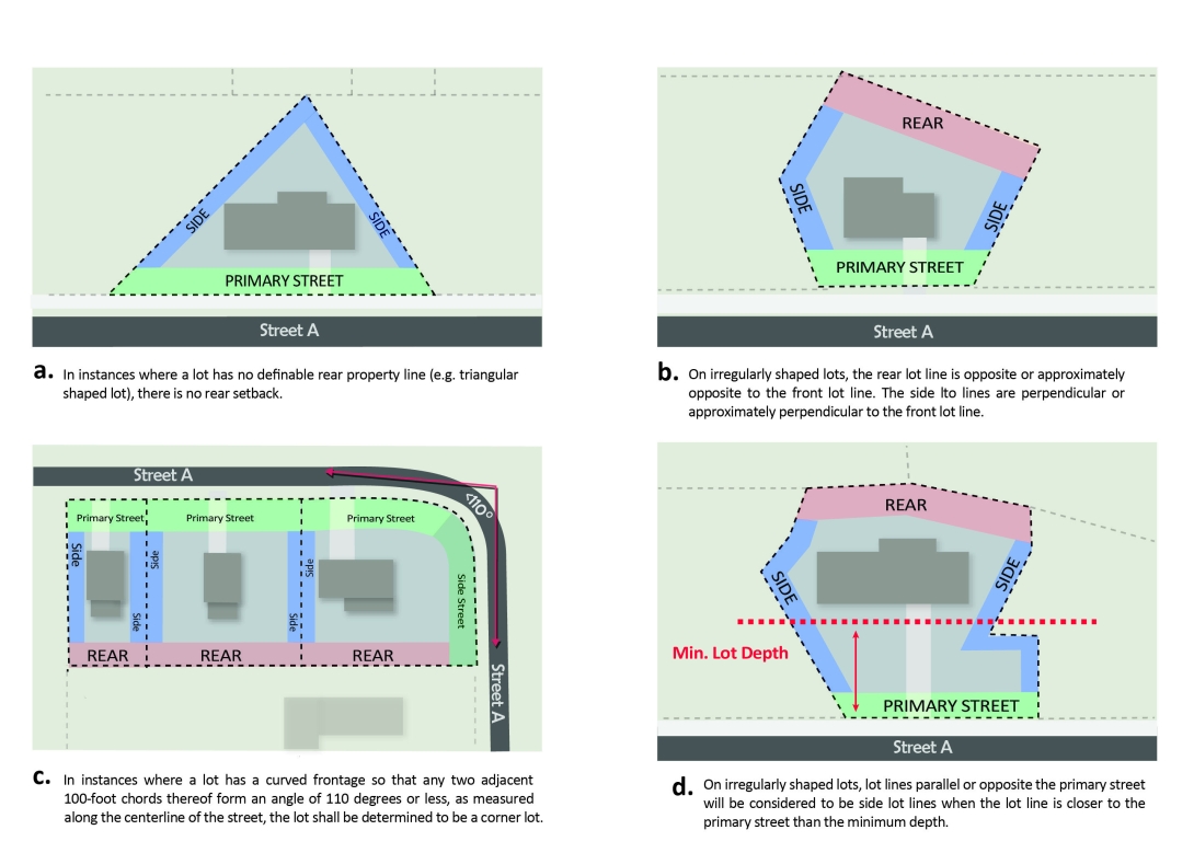
Site width is the distance between the side lot lines of the site (generally running perpendicular to a street) measured at the primary street property line along a straight line or along the chord of the property line.
D. Site Depth
Site depth is the distance between the front and rear property lines of the site measured along a line midway between the side property lines.
A. Defined
A parcel of land either vacant or occupied intended as a unit for the purpose, whether immediate or for the future, of transfer of ownership or possession or for development.
B. Lot Area
Lot area is the area included within the rear, side and front lot lines. It does not include existing or proposed right-of-way, whether dedicated or not dedicated to public use. District density applies, and may require larger lots than those required for an individual building type.
C. Lot Width
Lot width is the distance between the side lot lines (generally running perpendicular to a street) measured at the primary street property line along a straight line or along the chord of the property line. A lot must meet the minimum lot width for the entire minimum required depth of the parcel except for cul-de-sac lots. For townhouse lots that do not front on a public street, lot width is the distance between the side lot lines (generally running perpendicular to the parking lot or drive aisle) measured at the front property line along a straight line. A lot must meet the minimum lot width for the entire depth of the parcel except for cul-de-sac lots.
D. Lot Depth
Lot depth is the distance between the front and rear property lines measured along a line midway between the side property lines.

E. Lot Width and Depth for Cul-de-Sac Lots
Any lot abutting a cul-de-sac in a Residential District where the minimum lot width is not met at the front property line must comply with the following:
F. Density, Lot Area per Dwelling Unit, and Site Area per Dwelling Unit
Legacy Cluster Subdivisions
Legacy cluster subdivisions shall adhere to the setbacks set forth in Article 2.4 Conservation Development Option for the relevant building type.
There are 2 types of build-to -- primary street build-to and side street build-to. Through lots are considered to have at least 1 primary street build-to.The designation of the primary street build-to shall follow the rules of Sec. 1.5.4.C. No build-to is required on the non-primary street frontage of a through lot.

When any of the items listed below are generally perpendicular to the rightof- way and located within the applicable build-to range, lot width shall be reduced by the width of the impediment for the purposes of calculating build-to percentage. To qualify, a perpendicular impediment must reduce the build-to range to less than 10’ as detailed below. For example, a 100’ wide lot with a 20’ wide perpendicular easement would be considered an 80’ wide lot when calculating build-to percentage.

When any of the items listed below are generally parallel to the right-of-way, located within the build-to range, and reduce the build-to range to less than 5', then the build-to range shall be reduced by 50% and measured from the edge of the impediment. For example, a lot with a 17’ parallel easement and initial build-to range of 0'/20' shall be considered to have a new build-to range of 17’/27’.

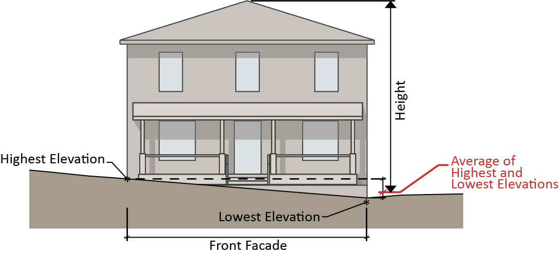
Building height is measured from average grade to the top of the highest point of a pitched or flat roof, not including a maximum parapet wall encroachment. Building height must be met for the entire building, unless the multiple module height method is used in which case building height must be met for each module. The maximum height encroachment for a parapet wall is 4 feet for a 3-story building, with 1 additional foot of parapet wall allowed for each additional story thereafter. In no case shall a parapet encroachment be taller than 12 feet.

Average grade for each module shall be considered to be average post-development grade above sea level along the building module elevation most parallel and closest to the primary street setback.

Single Building Height Method

Multiple Module Height Method

For any building subject to the standards of Sec. 2.2.7., average grade shall be determined by averaging the four points consisting of the highest and lowest elevations of both pre-development and postdevelopment grade above sea level along the building elevation most parallel and closest to the primary street setback. When the average post- development grade is lower than the average pre-development grade, then height shall be measured from the average post development grade.
The following subsections apply to any methodology:
Where a site or lot is determined to have more than one primary street, average grade shall be determined along each building or module elevation most parallel and closest to each primary street. Maximum building or module height must be met from the average grade of each primary street independently.

When using the multiple module height method, each module must establish an applicable elevation. The applicable module elevation is that which is most parallel and closest to the primary street, and20 feet or more in length. Any portion of the applicable module elevation that is located more than 30 feet behind the portion of the wall plane closest to the primary street shall not be included in the calculation of average grade, provided it is less than 50% of the total module elevation width.

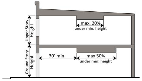
For a detached or attached building type only, an unfinished spaced that qualifies as an attic does not count as a story where 50% or more of the attic floor area has a clear height of less than 7.5 feet; measured from the floor to the ceiling.
A half-story shall be considered a habitable space between a roof and the ceiling of a room or rooms below where 50% or more of the floor area has a clear height of less than 7.5 feet; measured from the finished floor to the finished ceiling.

For a detached or attached building type only, or for any building type located within the Downtown Mixed Use District, or for any building that is zoned for a maximum of three stories, where a lot slopes downward from any primary street, one story that is additional to the specified maximum number of stories may be built on the lower portion of the lot. This provision shall not be applicable for any structure that includes a basement.

Where the property slope increases to the rear, building, or building module, height is measured from the average post-development grade above sea level of the front and rear wall plane of the building or building module. However, buildings subject to the standards of Sec. 2.2.7. shall utilize the same averaging approaches in Sec. 1.5.7.A.2.c. above, in order to calculate the average grade between the pre-development average grade and the post-development average grade. When the average post-development grade utilizing both the front and rear wall planes is lower than the average pre-development grade, then height shall be measured from the average post-development grade of the front and rear wall planes.

For buildings using the Multiple Module Height Method of Sec. 1.5.7.A.2.b, a higher or lower floor may be designated as the ground story for different portions of a building façade.

General Requirement

The Planning Commission or Design Review Commission performing the quasi-judicial duties of the Planning Commission (as designated by the City Council), after conducting a duly noticed quasi-judicial evidentiary hearing in accordance with Sec. 10.2.17., shall reduce the required transparency, if all of the following findings are satisfied:


