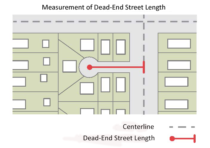
Avenue 4-Lane, Parallel Parking
| Width |
| A | Right-of-way width | 121' |
| B | Back-of-curb to back-of-curb | 72' |
| C | Intersections: Face of curb to face of
curb for width of cross-street sidewalk | 55-56’ |
| Streetscape |
| D | Sidewalk (min) | 10' |
| E | Planting area (min) | 6' |
| F | Bike lane | 5' |
| G | Buffer (min; planted, paved, or paver) | 3.5' |
| Travelway |
| H | Parallel parking lane | 8.5' |
| I | Travel lane | 11' |
| J | Median | 11' |
| General |
| | Walkway type | Sidewalk |
| | Planting type | Tree grate / lawn |
| | Tree spacing | 40' o.c. avg |
| | Parking type | Parallel |
| | Minimum Driveway Spacing | 300' |
The position of streetscape elements may be changed, provided that all of the following are met:
• No streetscape element is removed,
• That street trees are planted between the sidewalk (C) and the travelway,
• That street trees not be placed between the bike lane (E) and the travelway within 20 feet of a driveway or intersection, unless the bikeway crosses the driveway 20 lateral feet or more from the nearest turn or travel lane,
• That the sidewalk (C) remains at the outside edge of the right-of-way,
• That the bike lane (E) be located at least 3.5’ from the back of curb, and
• That the sidewalk (C) and bike lane (E) tie to any existing bikeways and/or sidewalks on adjacent sites.
Avenue 4-Lane, Divided
| Width |
| A | Right-of-way width | 109' |
| B | Back-of-curb to back-of-curb | 66' |
| Streetscape |
| C | Maintenance strip (min) | 1' |
| D | Sidewalk (min) | 6' |
| E | Planting area (min) | 6' |
| F | Bike lane | 5' |
| G | Buffer (min; planted, paved, or paver) | 3.5' |
| Travelway |
| H | Travel lane | 11' |
| I | Median | 17' |
| General |
| | Walkway type | Sidewalk |
| | Planting type | Tree grate / lawn |
| | Tree spacing | 40' o.c. avg |
| | Minimum Driveway Spacing | 300' |
The position of streetscape elements may be changed, provided that all of the following are met:
• No streetscape element is removed,
• That street trees are planted between the sidewalk (D) and the travelway,
• That street trees not be placed between the bike lane (F) and the travelway within 40 feet of a driveway or intersection, un
less the bikeway crosses the driveway 20 lateral feet or more from the nearest turn or travel lane,
• That the maintenance strip (C) remains at the outside edge of the right-of-way,
• That the sidewalk (D) remains adjacent to the maintenance strip (C),
• That the bike lane (F) be located at least 3.5’ from the back of curb, and
• That the sidewalk (D) and bike lane (F) tie to any existing bikeways and/or sidewalks on adjacent sites.
Avenue 6-Lane, Divided
| Width |
| A | Right-of-way width | 131' |
| B | Back-of-curb to back-of-curb | 88' |
| Streetscape |
| C | Maintenance strip (min) | 1' |
| D | Sidewalk (min) | 6' |
| E | Planting area (min) | 6' |
| F | Bike lane | 5' |
| G | Buffer (min; planted, paved, or paver) | 3.5' |
| Travelway |
| H | Travel lane | 11' |
| I | Median | 17' |
| General |
| | Walkway type | Sidewalk |
| | Planting type | Tree grate / lawn |
| | Tree spacing | 40' o.c. avg |
| | Minimum Driveway Spacing | 300' |
The position of streetscape elements may be changed, provided that all of the following are met:
• No streetscape element is removed,
• That street trees are planted between the sidewalk (D) and the travelway,
• That street trees not be placed between the bike lane (F) and the travelway within 40 feet of a driveway or intersection, unless the bikeway crosses the driveway 20 lateral feet or more from the nearest turn or travel lane,
• That the maintenance strip (C) remains at the outside edge of the right-of-way,
• That the sidewalk (D) remains adjacent to the maintenance strip (C),
• That the bike lane (F) be located at least 3.5’ from the back of curb, and
• That the sidewalk (D) and bike lane (F) tie to any existing bikeways and/or sidewalks on adjacent sites.
Multi-Way Boulevard, Parallel Parking
| Width |
| A | Right-of-way width | 154' |
| B | Back-of-curb to back-of-curb | 66' |
| Streetscape |
| C | C Sidewalk (min) | 10' |
| D | Planting area (min) | 6' |
| Access Lane |
| E | Parallel parking | 8.5' |
| F | Access lane | 11' |
| G | Median | 11' |
| Travelway |
| H | Travel lane | 11' |
| I | Median | 17' |
| General |
| | Walkway type | Sidewalk |
| | Planting type | Tree grate / lawn |
| | Tree spacing | 40' o.c. avg |
| | Parking type | Parallel in access lane |
Multi-Way Boulevard, Angle Parking
| Width |
| A | Right-of-way width | 177' |
| B | Back-of-curb to back-of-curb | 66' |
| Streetscape |
| C | Sidewalk (min) | 10' |
| D | Planting area (min) | 6' |
| Access Lane |
| E | Parallel parking | 8.5' |
| F | Access lane | 11' |
| G | Median | 11' |
| Travelway |
| H | Travel lane | 11' |
| I | Median | 17' |
| General |
| | Walkway type | Sidewalk |
| | Planting type | Tree grate / lawn |
| | Tree spacing | 40' o.c. avg |
| | Parking type | 60°angle in access lane |
Busway 2-Lane
| Width |
| A | Right-of-way width | 126' |
| B | Back-of-curb to back-of-curb | 83' |
| Streetscape |
| C | Maintenance strip (min) | 1' |
| D | Sidewalk (min) | 6' |
| E | Planting area (min) | 6' |
| F | Bike Lane (min) | 5' |
| G | Buffer (min; planted, paved, or paver) | 3.5' |
| Travelway |
| H | Curb and Gutter | 2.5' |
| I | Travel lane | 11' |
| J | Median | 16' |
| Busway |
| K | Busway | 24' |
| General |
| | Walkway type | Sidewalk |
| | Planting type | Tree grate / lawn |
| | Tree spacing | 40' o.c. avg |
The position of streetscape elements may be changed, provided that all of the following are met:
• No streetscape element is removed,
• That street trees are planted between the sidewalk (D) and the travelway,
• That street trees not be placed between the bike lane (F) and the travelway within 20 feet of a driveway or intersection, unless the bikeway crosses the driveway 20 lateral
• feet or more from the nearest turn or travel lane,
• That the maintenance strip (C) remains at the outside edge of the right-of-way,
• That the sidewalk (D) remains adjacent to the maintenance strip (C),
• That the bike lane (F) be located at least 3.5’ from the back of curb, and
• That the sidewalk (D) and bike lane (F) tie to any existing bikeways and/or sidewalks on adjacent sites.
Busway 4-Lane
| Width |
| A | Right-of-way width | 144' |
| B | Back-of-curb to back-of-curb | 101' |
| Streetscape |
| C | Maintenance strip (min) | 1' |
| D | Sidewalk (min) | 6' |
| E | Planting area (min) | 6' |
| F | Bike Lane (min) | 5' |
| G | Buffer (min; planted, paved, or paver) | 3.5' |
| Travelway |
| H | Curb and Gutter | 2.5' |
| I | Travel lane | 10' |
| J | Median | 16' |
| Busway |
| K | Busway | 24' |
| General |
| | Walkway type | Sidewalk |
| | Planting type | Tree grate / lawn |
| | Tree spacing | 40' o.c. avg |
The position of streetscape elements may be changed, provided that all of the following are met:
• No streetscape element is removed,
• That street trees are planted between the sidewalk (D) and the travelway,
• That street trees not be placed between the bike lane (F) and the travelway within 40 feet of a driveway or
intersection, unless the bikeway crosses the driveway 20 lateral feet or more from the nearest turn or travel lane,
• That the maintenance strip (C) remains at the outside edge of the right-of-way,
• That the sidewalk (D) remains adjacent to the maintenance strip (C),
• That the bike lane (F) be located at least 3.5’ from the back of curb, and
• That the sidewalk (D) and bike lane (F) tie to any existing bikeways and/or sidewalks on adjacent sites.
Busway 6-Lane
| Width |
| A | Right-of-way width | 164' |
| B | Back-of-curb to back-of-curb | 121' |
| Streetscape |
| C | Maintenance strip (min) | 1' |
| D | Sidewalk (min) | 6' |
| E | Planting area (min) | 6' |
| F | Bike Lane (min) | 5' |
| G | Buffer (min; planted, paved, or paver) | 3.5' |
| Travelway |
| H | Curb and Gutter | 2.5' |
| I | Travel lane | 10' |
| J | Median | 16' |
| Busway |
| | K Busway | 24' |
| General |
| | Walkway type | Sidewalk |
| | Planting type | Tree grate / lawn |
| | Tree spacing | 40' o.c. avg |
The position of streetscape elements may be changed, provided that all of the following are met:
• No streetscape element is removed,
• That street trees are planted between the sidewalk (D) and the travelway,
• That street trees not be placed between the bike lane (F) and the travelway within 40 feet of a driveway or intersection, unless the bikeway crosses the driveway 20 lateral feet or more from the nearest turn or travel lane,
• That the maintenance strip (C) remains at the outside edge of the right-of-way,
• That the sidewalk (D) remains adjacent to the maintenance strip (C),
• That the bike lane (F) be located at least 3.5’ from the back of curb, and
• That the sidewalk (D) and bike lane (F) tie to any existing bikeways and/or sidewalks on adjacent sites.